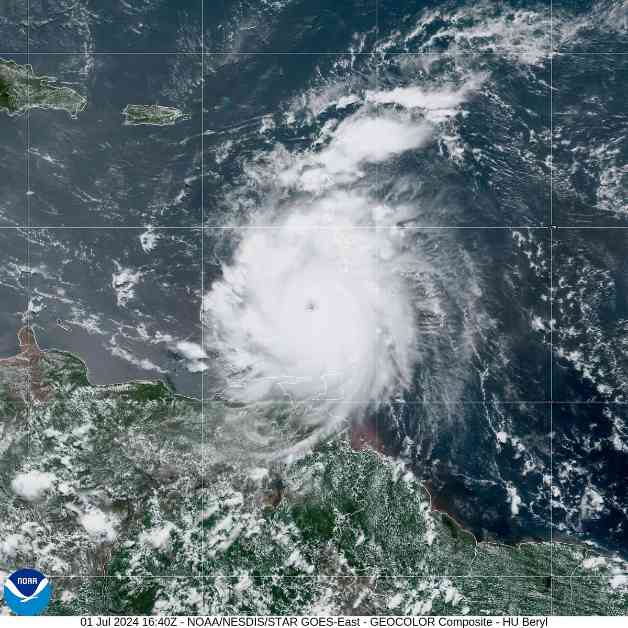
Hurricane Beryl’s rapid intensification has taken meteorologists by surprise, setting a record as the earliest Category 4 storm in the Atlantic Ocean basin. This unprecedented event is a cause for concern as it may be a sign of what is to come for the rest of the hurricane season.
The warm ocean waters in the Atlantic, Caribbean, and Gulf of Mexico are currently at peak hurricane season temperatures, providing ideal conditions for storm development. Additionally, the shift from El Niño to La Niña climate patterns is altering atmospheric circulation patterns, making it more favorable for hurricanes to form and strengthen.
Before Beryl, no hurricane had ever formed so far east in June, making it an exceptional and alarming event. The rapid intensification of the storm, with wind speeds increasing by 63 mph in just 24 hours, is highly unusual for this time of year. This trend of rapid intensification is expected to continue as the climate warms.
The impact of such strong storms, like Beryl, can be devastating, especially in areas that are not accustomed to major hurricanes. The Windward Islands, where Beryl made landfall, are particularly vulnerable to these intense storms. The lack of preparation and infrastructure in these regions can lead to significant damage and loss of life.
As the hurricane season progresses, experts predict that more storms will set records and catch people off guard. The forecast for this season includes a higher number of named storms, hurricanes, and major hurricanes than average. This means that communities in hurricane-prone areas need to be vigilant and prepared for the possibility of more intense storms in the coming months.
The unprecedented rapid intensification of Hurricane Beryl serves as a stark reminder of the increasing impact of climate change on extreme weather events. The need for adaptation and resilience measures is more critical than ever as we face the challenges of a changing climate.


